SEALS Home
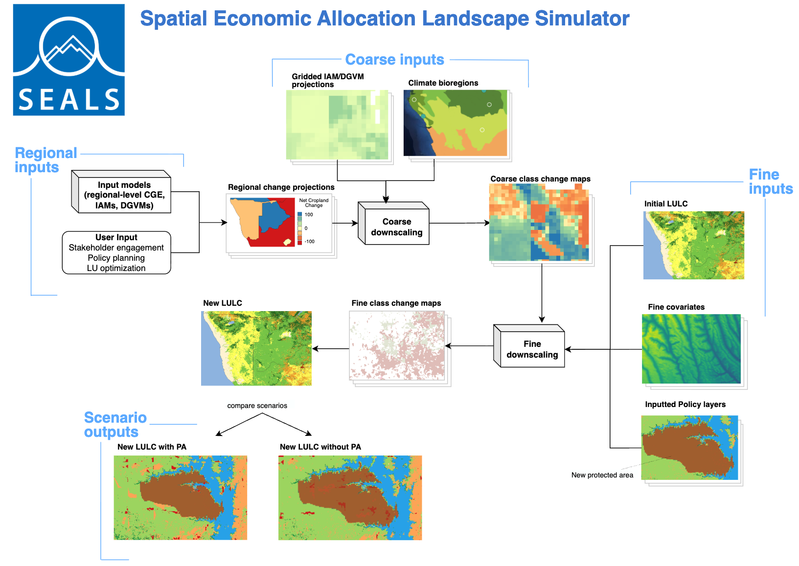
SEALS, the Spatial Economic Allocation Landscape Simulator, is a land-use change model that downscales projections of land-use change from aggregate (regional or coarse-gridded) inputs to a much finer resolution, typically 10–300 meters. See the User Guide for the full documentation.
Coarse economic and integrated-assessment models tell you how much cropland, pasture or forest a region gains or loses. They cannot tell you where. SEALS answers that question, which is what makes it possible to run spatially explicit ecosystem service models on economic scenarios.
What makes it distinctive
Speed. SEALS downscales to 300 meters globally — roughly 8.4 billion grid cells — in about an hour on a laptop. Performance-critical functions are written in C++ via Cython; everything else is Python.
Scalability. It is designed for parallel execution, so it scales from a laptop to high-performance, cloud, or distributed computing.
Source-agnostic inputs. It downscales from coarse gridded projections (LUH2, MAgPIE) or from regional totals (regional polygons from a CGE model such as GTAP-AEZ), or from both at once.
Reproducibility. Runs are driven by a scenarios CSV rather than by edited code, and every step is cached, so an interrupted run resumes instead of restarting.
SEALS is a part of the Earth-Economy Devstack, a software platform supported by NatCap TEEMs (The Earth-Economy Modellers).
Where it fits
SEALS is the land-use step inside GTAP-InVEST: GTAP-AEZ produces regional land-use change, SEALS downscales it to 300 m, and InVEST computes the resulting ecosystem service changes. It is equally usable on its own, or coupled to any other model that produces coarse land-use projections.
SEALS was first introduced in Suh et al. (2020), Global Environmental Change, which used it to downscale cropland expansion projections to ~300m resolution. It was later coupled to GTAP-AEZ in the Global Futures work (Johnson et al. 2020, WWF; 2021, World Bank) and to MAgPIE in von Jeetze et al. (2023), Nature Communications. It became the downscaling component of GTAP-InVEST in Johnson et al. (2023), PNAS, with the full model description in Johnson et al. (in review).
Documentation and code
Install:
mamba install sealsmodelin a conda environment gets you SEALS, hazelbean and the geospatial stack from conda-forge, prebuilt for Windows, macOS and Linux. (The package is namedsealsmodel; the import isimport seals.) Developers who want to change SEALS make an editable install from a clone instead — see the installation page.SEALS User Guide — installation, a first run, the scenarios CSV reference, and coupling to other models. Also available as a single PDF.
GitHub: jandrewjohnson/seals — all code, under a permissive open-source license.
Earth-Economy Devstack — the shared platform SEALS is built on: hazelbean, ProjectFlow, and the conventions every model in the stack follows.
SEALS is under active development and changes rapidly. Pull the latest seals before reporting a problem.